North Richmond Living Levee Project
What is a Living Levee?

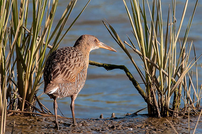
California Ridgeway's Rail

A living levee is a natural, sloped wall made of repurposed earth and layers of native plants built to protect against damaging coastal floods.
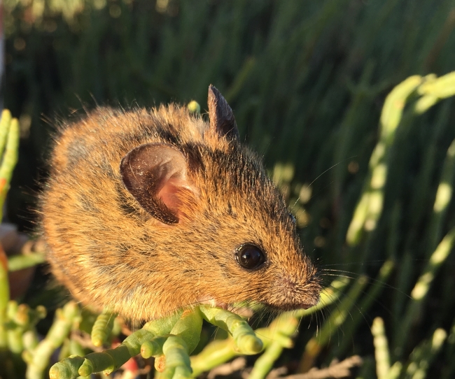
The North Richmond shoreline contains some of the best intact tidal and wetland marshes in the San Francisco Bay and is home to several threatened species, such as the California Ridgway’s rail and the Salt Marsh Harvest mouse, shown above.
A living levee will preserve the habitat for plants and animals in addition to protecting people and property from coastal flooding.
Flood Increase Projection Map
Hover over the letters on the map for more information.
Map of North Richmond indicating the locations of the living levee and WCW’s Water Quality and Resource Recovery Plant.
White Line: Bay Trail and connecting trails | Magenta Area: Levee slope
Legend
White Line: Bay Trail and connecting trails
Magenta Area: Levee slope
- Point Pinole Shoreline Regional Park
- San Pablo Creek
- Landfill
- West County Wastewater Treatment Plant
- Castro Cove
- Wildcat Creek
- Chevron Refinery
What is a Living Levee?

California Ridgeway's Rail

A living levee is a nature-based flood solution that incorporates a gradual slope and layers of native plants to protect against sea level rise and flooding.
The North Richmond shoreline contains some of the best intact tidal and wetland marshes in the Bay and is home to several threatened and endangered species, such as the California Ridgway’s rail and salt marsh harvest mouse (see above). Using a living levee will preserve the habitat for plants and animals in addition to protecting people and property from coastal flooding.
Flood Increase Projection Map
Protecting North Richmond from flood
Winter storm surges and extreme weather patterns are causing flood concerns for the communities within North Richmond. We are working with our community to protect the businesses and residents within these low-laying areas along the North Richmond shoreline from Castro Cove to Point Pinole Shoreline Regional Park.
We expect that frequent flooding during storms and high tides will effect North Richmond by 2050.
WCW has been working with community partners, including the San Francisco Bay Restoration Authority to design and build an innovative “living levee”. This project is part of the North Richmond Collaborative Shoreline Plan and aims to protect the infrastructure at our plant and nearby neighborhoods from flooding, while preserving the wetlands along the shoreline.
Features of a Living Levee
Hover over the numbers in the image below to learn more about the parts of the living levee.
Legend
1. Tidal Marsh – Wetland habitat that is home to several threatened and endangered species and protects the shoreline from erosion.
2. Transition Zone – A gentle slope creates a transition zone between upland and tidal marsh habitats, providing high tide refuge and migration space for local wildlife and plants. This zone will also protect our area against storm surges and absorb floodwater.
3. Upland Habitat – Restored upland habitats include ponds, grasslands, and woodlands, providing a higher layer of flood protection.
4. Bay Trail – Planned San Francisco Bay Trail enhancements will increase the community’s access to trails and the shoreline, along with protecting the shoreline ecosystem from human disturbance.
5. Stormwater Infrastructure – Inland green stormwater infrastructure, such as bioretention ponds, absorbs additional water, further increasing our resilience to storms and floods.
6. Protected WCW’s Water Quality and Resource Recovery Plant – The living levee will provide vital protection to WCW’s infrastructure, including our new Clean & Green Project, and the community of Richmond.
Timeline and Recent Updates
Summer 2020
WCW awarded grant from SFBRA to conduct a feasibility study for a flood resiliency project.
Spring 2022
Organized stakeholder and community working group meetings and development of the Collaborative Shoreline Plan.
Winter 2023
Completed the 30% preliminary planning and design work for both the flood resiliency project and the Collaborative Shoreline Plan.
Spring 2024
SFBRA awarded WCW a $1.85 million grant to continue the planning and design efforts for the flood resiliency project.
Spring 2025
WCW Board of Directors approved a contract with Mithun to continue the planning and design efforts.
Partnerships for Coastal Resilience in North Richmond
WCW’s grant from the San Francisco Bay Restoration Authority (SFBRA) to develop the living levee is part of the broader vision outlined in the North Richmond Collaborative Shoreline Adaptation Plan. The plan provides recommendations to prepare the shoreline for climate change to protect our habitats and communities for the future. Based on the community’s input, the plan also includes projects to improve public access to the shoreline, such as elevated boardwalks, and improvements to the San Francisco Bay Trail.
The plan builds on the work of previous shoreline planning efforts focused on preservation and resilience, including the following:
- North Richmond Shoreline Community Vision (2017, San Francisco Estuary Partnership)
- Resilient by Design Challenge (2018, The Watershed Project and Mithun, Inc.)
- Contra Costa Resilient Shoreline Plan (Contra Costa County)
- Richmond Parkway Transportation Plan (2024, Caltrans and West Contra Costa Transportation Commission)
- Wildcat Creek Trail Visioning Project (Urban Tilth and Wildcat-San Pablo Creeks Watershed Council)


